Mitsubishi Electric just beat Google to one of self-driving cars’ most significant hurdles
The Japanese company has come up with a method for autonomously driving in the snow
·
In the drive to get autonomous cars on the road, one major hurdle remains – snow.
In 2015, Google admitted that despite the myriad, highly accurate sensors on its self-driving cars, one of its biggest challenges in mapping roads in real time is navigating changing weather conditions. To overcome rain, Google's Waymo team fitted windscreen wipers to its cameras, but it’s still yet to fully master mapping the terrain in snow. Step up, Mitsubishi Electric.
Snow, you see, causes havoc with systems that base their decisions on reflected light from road markings. Much like throwing a white blanket over the road, snow masks the information autonomous cars need to drive safely. The Japanese company has come up with a method for getting around this with a “position-augmenting” algorithm, which uses GPS data to correct errors caused by masked roads.
Not to be confused with Mitsubishi Motors, Mitsubishi Electric is the Japanese giant’s robotics, engineering and AI business probably best known in the West for air conditioners. It was a household name in the UK in the 1980s due to its now discontinued TV and VCR ranges.
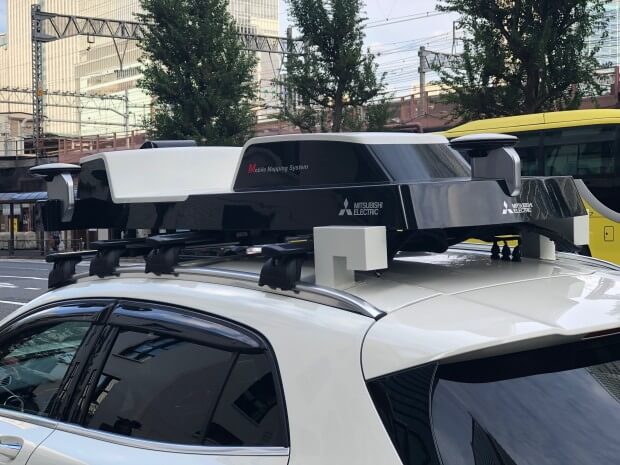
Back at CeBIT in March, ME unveiled its AI-powered Mobile Mapping System (MMS). MMS uses cameras and sensors to create “highly precise dynamic 3D maps that provide information of roads and surrounding objects”.
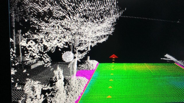
The system’s sensors, which can be fitted onto any family-sized car, create so-called laser-point clouds. The lasers are fired at objects and the AI plots the reflections and shadows that are returned to create a polka-dot image of everything in its path. By using a mix of laser scanners, camera and GPS while driving, objects are mapped with a precision of 10cm or less. The aim being that such maps will be used for autonomous driving, among other things.
This is not a new technology, but ME’s algorithms and sensor setup are said to make MMS up to 10 times faster, and cheaper, than manual methods. The key differential being ME’s “difference extraction” technology that automatically plots only what’s changed in a landscape since the last time it was scanned. By only sending these changes, rather than the entire landscape each time the map is updated, it significantly speeds up the process and saves power and cost.
Like other sensors, however, looking for reflections from road markings via MMS are impossible in snow when they're masked by a white "blanket." To overcome this, Mitsubishi Electric has started trialling a “centimeter-level augmentation service”, or CLAS, being broadcast from Japan’s Quasi-Zenith Satellite System (QZSS). ME is the main government contractor for the technology.
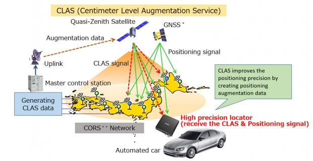
CLAS complements MMS. It takes data from GPS satellites as well the readings from ground-based sensors to identify the location of cars before applying a “position-augmenting” algorithm that corrects for errors. Typically, GPS is accurate to within five to 10 metres; CLAS’ augmentation software reduces this to centimetres. It has six bands, where GPS has three, and can see at a 45-degree angle. GPS can see at a 15-degree angle.
To put this into perspective, a recent independent study into the viability of automated driving systems claimed the technology would need to be accurate to within 25cm – CLAS is accurate to 12cm on the horizontal plane and 24cm vertically.
Using this higher level of accuracy in snowy conditions means the car will already know the layout of the road from the MMS 3D maps and will navigate without the need for lane markings. This is because there is a smaller margin of error as it crosses over, thanks to CLAS. Mitsubishi Electric has already successfully trialled a car fitted with MMS through a cone obstacle course in the snow and plans to further these tests.
The field testing of CLAS began on 19 September and it is scheduled to begin operating fully in April 2018, following full verification. Although it works with MMS and has potential to significantly speed up the introduction of self-driving cars in Japan, it will be used in the first instance to offer more accurate, everyday navigation for drivers, businesses and pedestrians navigating across Japan.
It is being introduced in Japan due to the unique position of Japan’s QZSS and its accompanying satellites that create a figure-of-eight-style orbit directly above the country. This means QZSS is always sending and receiving signals, unlike geo-stationary orbits that only pass over countries at various parts of the day as they move around the Earth. Japan currently has around 1,300 electric reference points and ME has selected 30 of these for the trials, each with a gap of 50km MILES between. In theory, taking readings from more sensors could improve accuracy further but would require more processing power, and may delay signals.
Ahead of self-driving cars running MMS by default, ME is in discussion with the government and Yamato Corporation to fit MMS to company trucks to constantly be updating the maps as they make their deliveries. There are also proposals to fit them to police vehicles and other cars that regularly drive city streets in the future.
A CLAS receiver is due to launch in Asia-Pacific under Sapcorda Services next year and there are plans to extend it across the globe.
Mitsubishi Electric just beat Google to one of self-driving cars’ most significant hurdles
The Japanese company has come up with a method for autonomously driving in the snow

In the drive to get autonomous cars on the road, one major hurdle remains – snow.
In 2015, Google admitted that despite the myriad, highly accurate sensors on its self-driving cars, one of its biggest challenges in mapping roads in real time is navigating changing weather conditions. To overcome rain, Google's Waymo team fitted windscreen wipers to its cameras, but it’s still yet to fully master mapping the terrain in snow. Step up, Mitsubishi Electric.
Snow, you see, causes havoc with systems that base their decisions on reflected light from road markings. Much like throwing a white blanket over the road, snow masks the information autonomous cars need to drive safely. The Japanese company has come up with a method for getting around this with a “position-augmenting” algorithm, which uses GPS data to correct errors caused by masked roads.
Not to be confused with Mitsubishi Motors, Mitsubishi Electric is the Japanese giant’s robotics, engineering and AI business probably best known in the West for air conditioners. It was a household name in the UK in the 1980s due to its now discontinued TV and VCR ranges.

Back at CeBIT in March, ME unveiled its AI-powered Mobile Mapping System (MMS). MMS uses cameras and sensors to create “highly precise dynamic 3D maps that provide information of roads and surrounding objects”.
The system’s sensors, which can be fitted onto any family-sized car, create so-called laser-point clouds. The lasers are fired at objects and the AI plots the reflections and shadows that are returned to create a polka-dot image of everything in its path. By using a mix of laser scanners, camera and GPS while driving, objects are mapped with a precision of 10cm or less. The aim being that such maps will be used for autonomous driving, among other things.
READ NEXT: What is LIDAR?
This is not a new technology, but ME’s algorithms and sensor setup are said to make MMS up to 10 times faster, and cheaper, than manual methods. The key differential being ME’s “difference extraction” technology that automatically plots only what’s changed in a landscape since the last time it was scanned. By only sending these changes, rather than the entire landscape each time the map is updated, it significantly speeds up the process and saves power and cost.
Like other sensors, however, looking for reflections from road markings via MMS are impossible in snow when they're masked by a white "blanket." To overcome this, Mitsubishi Electric has started trialling a “centimeter-level augmentation service”, or CLAS, being broadcast from Japan’s Quasi-Zenith Satellite System (QZSS). ME is the main government contractor for the technology.
CLAS complements MMS. It takes data from GPS satellites as well the readings from ground-based sensors to identify the location of cars before applying a “position-augmenting” algorithm that corrects for errors. Typically, GPS is accurate to within five to 10 metres; CLAS’ augmentation software reduces this to centimetres. It has six bands, where GPS has three, and can see at a 45-degree angle. GPS can see at a 15-degree angle.

To put this into perspective, a recent independent study into the viability of automated driving systems claimed the technology would need to be accurate to within 25cm – CLAS is accurate to 12cm on the horizontal plane and 24cm vertically.
Using this higher level of accuracy in snowy conditions means the car will already know the layout of the road from the MMS 3D maps and will navigate without the need for lane markings. This is because there is a smaller margin of error as it crosses over, thanks to CLAS. Mitsubishi Electric has already successfully trialled a car fitted with MMS through a cone obstacle course in the snow and plans to further these tests.
The field testing of CLAS began on 19 September and it is scheduled to begin operating fully in April 2018, following full verification. Although it works with MMS and has potential to significantly speed up the introduction of self-driving cars in Japan, it will be used in the first instance to offer more accurate, everyday navigation for drivers, businesses and pedestrians navigating across Japan.
READ NEXT: How do Google's self-driving cars work?
It is being introduced in Japan due to the unique position of Japan’s QZSS and its accompanying satellites that create a figure-of-eight-style orbit directly above the country. This means QZSS is always sending and receiving signals, unlike geostationary orbits that only pass over countries at various parts of the day as they move around the Earth. Japan currently has around 1,300 electric reference points and ME has selected 30 of these for the trials, each with a gap of 50km MILES between. In theory, taking readings from more sensors could improve accuracy further but would require more processing power, and may delay signals.
Ahead of self-driving cars running MMS by default, ME is in discussion with the government and Yamato Corportation to fit MMS to company trucks to constantly be updating the maps as they make their deliveries. There are also proposals to fit them to police vehicles and other cars that regularly drive city streets in the future.
A CLAS receiver is due to launch in Asia-Pacific under Sapcorda Services next year and there are plans to extend it across the globe.
